


Words & Photos by Paul Burbidge
The May long weekend is the year’s first real chance to get out in the mountains and paddle. In 2016 our plans had been thwarted by a faulty river gauge that was reading 10 times the actual flow. In 2017 our plans weren’t looking good due to too little water in the rivers we wanted to paddle and too much snow in the mountains we needed to cross.
Our last minute substitution was to paddle the Kaskawulsh River in Kluane National Park. Access would be up the Slims River Valley and out via the Alsek River Trail. None of us were really excited about the amount of flat hiking involved in this route and we knew the Kaskawulsh would be pretty tame, so we decided that we’d use fat bikes in addition to our pack rafts.
Dave Gonda, Dylan Stewart and I got out of town on Friday afternoon, stopped in Haines Junction to register our trip with Parks Canada, and were underway at the Slims River by 6 pm.
For approximately the last 300 years the Kaskawulsh Glacier has fed two rivers, the Kaskawulsh and the Slims.
The Kaskawulsh River flows east from the glacier for about 50km before merging with the Dezadeash River and becoming the Alsek River. The Slims River flowed into Kluane Lake which is eventually discharged into the ocean by the Yukon River. The Yukon and Alsek discharges are located 1500 kilometers apart on the Alaskan coast.

In Spring 2016, a change in the Kaskawulsh Glacier cut off water supply to the Slims River. More information can be found here.
This change made our route appealing in two ways; it provided a (hopefully) good fat biking surface up the Slims Valley and lots of water for the Kaskawulsh River. Most rivers were running low in Yukon due to a late Spring; we hoped the divergence of water to the Kaskawulsh would mean this wasn’t the case on our route.
We set out on the Slims East trail. Many portions of this trail are overgrown or washed away. It was tempting to just head for the riverbed and ride up, however the dust blowing down the river indicated that the normal dusty winds were blowing strongly.
The Slims Valley often has very strong winds transporting glacial dust down valley and into Kluane Lake. I imagine the amount of dust has increased since 2016 due to the lack of water in the valley.

After one misguided foray involving leaving the river bed-searching for trail, terrible bushwhacking, finding the trail, and carrying our bikes on overgrown trail, we decided to go with the devil we knew. The devil being the dusty winds of the open former river bed.
Once on the river we rode into the headwind and made good progress up valley. There is still a bit of water in the river bed due to tributary creeks that used to add to the Slims River. This water was easily crossed by carrying our bikes and was knee-deep at the deepest. The closer we got to the glacier the less water was in the valley.

We’d been warned about quick mud that may make the river bed dangerous. The river was named after Slim, a horse that got stuck in this mud and drowned many years ago. We found a few sticky spots but nothing harrowing.

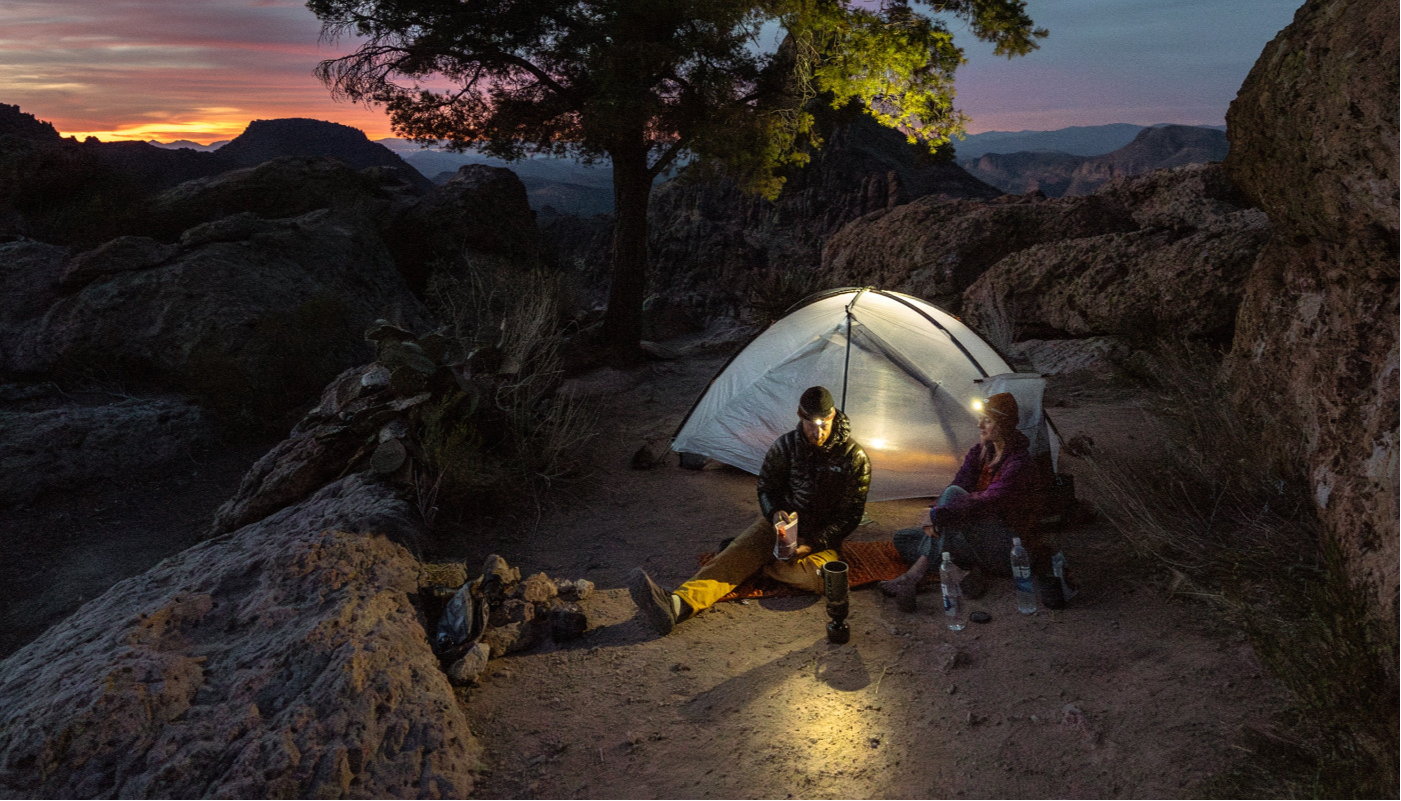
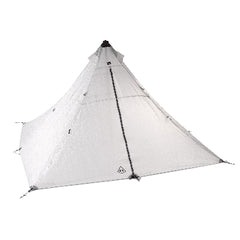
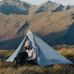
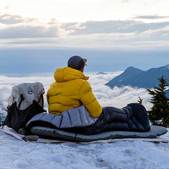
After a few hours we decided to make camp in an area sheltered from the wind. We threw up our new Ultamid 4 and got a nice fire going. We spent the night trading stories, trying to warm our feet and watching a bear across the valley.

In the morning we were back underway with about an hour’s ride to the glacier. Of note to anyone wanting to ride to the glacier on the riverbed:
- There is less and less water to deal with as you make progress toward the glacier
- The riding surface gets better the closer you get (from silt to dirt to gravel to rocks)
- My guess is that the river bed would not be easy in mid summer due to water from the tributary creeks. I’d go up the west side later in the year.

Once we got near the glacier we ditched the bikes and hiked around to check out the glacier. It was quickly obvious that we couldn’t start boating here as the river went under the glacier. We backtracked a bit and started biking down the Kaskawulsh Valley.

After about an hour of very fun riding we got below a frozen lake that the river runs through and blew up the boats. We lashed our bikes on the bows and started the descent of the Kaskawulsh.


The Kaskawulsh had plenty of water and a good current. There were no rapids to speak of other than two which were Class 2+ at the level we paddled. We had a headwind, rain and cold water for almost the whole paddle. We made one warm-up stop and were ready to call it a day when we saw campers and a fire at the Jarvis confluence.


The campers were Sean and Travis. They had started on the same route a few hours earlier than us on Friday. They were hiking and rafting and offered to share their fire and campsite with us. We spent a rainy night talking trips and rafts and other fun things.


In the morning Travis and Sean took off before us while we lazed around. There had been animals about 1 kilometer away on the other side of the river since the previous night. I paddled over to get a photo and confirm what they were. They turned out to be bison which was interesting because I don’t think they are often (or ever?) seen in the park. I’ve passed this information onto Parks Canada.

We saw a few moose and about 250 sheep as we made our way down river.
It had rained all night and didn’t let up on the river–nor did our headwind. Dave’s hands got pretty cold and he entertained us with his chicken dance warming method. Dylan and I both had insulated sleeping pads in the floor of our boats which kept us warmer than Dave.


After 2-3 hours of paddling we pulled out and started transitioning back to bikes. Dylan and Dave got a fire going while I found the Alsek River Trail and a route to access it.
Once we were on the bikes the wind was finally in our favor. It took us only 1.5 hours to cruise out the 25km of trail and arrive at the highway. We passed Sean and Travis who had come a long way since we last saw them at the take out. From the highway it was a 2 minute ride to my friend Geoff’s place where we borrowed a truck to retrieve my truck.
Thanks to Dave and Dylan for an awesome trip. Looking forward to many more this season.


