
Pile It On – Packrafting a First Descent in Lake Clark National Park, Alaska
Words by Roman Dial // Photos by Mike Curiak
Midway through a six-mile, ten-hour day, Brad Meiklejohn asked his packrafting partner, Roman Dial, “What are you going to tell people about this route?”
“The brush…” he responded. The hellish brush…
Hyperlite Mountain Gear Ambassadors and expert multi-sport adventurers Meiklejohn, Roman Dial and Mike Curiak had embarked on a two-week packrafting/thru hiking (aka bushwhacking) adventure in Alaska’s Lake Clark National Park. The team had just climbed off a 15-mile paddle and sail in packrafts across Lake Kontrashibuna, where they contended with miles and miles of some gnarly bushwhacking—really gnarly bushwhacking—in order to do the first descent of The Pile River (aka the “Pile it On” packrafting adventure).
“We had to wrestle with and wiggle through brush at the pathetic rate of four hours to the mile,” Dial says. “That’s serious class IV brush, requiring full body weight to fight through and threatening to break an arm or a leg should you topple. In ten hours we made 5.5 miles.”
 Lake Clark National Park, an hour’s flight west of Anchorage, is four million acres of mountains, glaciers, lakes, forests, brush, tundra and coastline—an area the size of four Yellowstone National Parks that lies at the junction of the Alaska and Aleutian Ranges.
Meiklejohn, president of the American Packrafting Association, had picked the 70-mile route the three adventurers would embark on. “It looked to be an instant classic—at least on the map,” says Dial. The route, he added, followed the only maintained trail in the park for a few miles to a long, skinny lake reaching deep into the mountains. From there it proceeded along “BMW” trails (trails made and maintained by Bear, Moose, and Wolf) for a dozen miles to a slot between alpine glaciers. And then descended to the Pile River, a 30-mile river that would take them to Alaska’s biggest body of water, Lake Iliamna (one of only two lakes with freshwater seals).

“Besides the mountains, lakes, wilderness, and wildlife, part of what appealed to Brad, Mike Curiak, and me was that the Pile River had no recorded descent. We would be the first,” Dial explains. “While being first up a mountain or down a river is exciting, it can also be a bit nerve-racking, especially when the river looks from the map to have a possible waterfall suggested by contours bunched up on the topo map.” And, indeed, the team found waterfalls, some of the worst bushwhacking they had ever experienced, plus numerous other obstacles. But they persevered, until they had finally completed the first descent of the Pile River in about a week.
Roman Dial’s Highlights
Day 2:
On day two we decided to paddle across the swollen Ospook early to avoid attempting to cross its canyon later on. But this was little more than a bid to be penny wise and dollar foolish. We ended up on river left, which steep, deep, foot-cramping “sponga” (mossy tundra) interspersed with alder hells on a north-facing slope. And with Ospook dropping at a Class V gradient with spring run-off flows, we were stuck with our choice of river left. Too deep to wade, too steep to paddle, with no eddies in a flooding river in the bushes, we only found a couple places we could cross easily, even then only by blowing up the packrafts and ferrying across. We finally made our way to safety by following a bear trail across side gorges and alder thickets.
Day 3:
On day 3 we found more of the same. But the devil we didn’t know seemed far less menacing than the devil we did, skulking as he was in the bushes behind us. Bear trails in summer maintained by moose in winter meant good going until a willow thicket. There, the moose fan out in search of food and we swam through supple, but cat-o-nine tails sharp, head-high bushes in Class III brush.
Eventually we broke above brush line, hobbled over moraines and other talus rubble, flushing white-tailed ptarmigan and golden-crowned sparrows nesting in the alpine. We made camp in a meadow, taking shelter as a thunderstorm past by, cooling us after three days of hot, sunny weather, but doing nothing to lower the swollen rivers and creeks. I wondered what the unexplored Pile River would be like at peak run-off.
Day 4:
Day 4 was a joy of kicking steps up firm snow below crenellated granite ridges, sharp horns and spires with thousand-foot cascades tumbling down polished walls. A bear trail led away from the pass, marked by paw prints worn inches deep into the crowberry tundra. We milked the downhill, boulder-hopping talus, and tundra skipping at speeds that washed away the memory of the two previous days.
Of course all good things (and bad) must come to an end. We eventually met the waiting brush line, which has been rising at a rate commensurate with climate change over the last few decades. Brad displayed his years of Alaskan wilderness experience by linking bear trails with meadows, getting us down to the Pile River by late afternoon.
The river, a glacier-stained blue and pulsing in the bushes, dropped steeply like a fish ladder in flood. Three times we got out and scouted long, surging rapids, discussing routes and lines and obstacles, holes that’d flip us and hold us, and wood and sieves to avoid. For about a mile, there was a Class III rapid at each bend. The river was mostly Class III, with a corner or two pushing Class IV. Then the river let up into steep gradient Class II, non-stop for a mile or more at a time with big, Grand Canyon style waves crashing over our heads. Moving at six or seven miles an hour, we made good time to a sandy island beach camp with a porcupine stranded by the waters.

Day 5:
Paddling between snow-topped granite mountains, we reached the anticipated canyon. We thought for sure it hid a waterfall, as we’d seen no fish. At the mouth of the canyon the river is forced into a tight constriction between rocky banks and a granitic island. Just upstream the current circulated slowly in a giant pool. We pulled out to scout.
Brad took one look at the entrance drop and started packing for the portage. Mike, fresh from high water runs in Idaho, said it looked like the Selway River without that classic wilderness run’s recovery pools. I saw river-wide ledge holes stacked one above the other. And in the last couple trips when Brad walked and I didn’t, I too often flipped and had to get back into my boat with a wet entrance.
I packed for the portage, too.
Our camp was spectacular, next to granite boulders on top of a 50-foot cliff where we watched a playful seal spy-hop to watch us watch him. Lake Iliamna is almost 80 miles long and ringed on the east by tundra-clad mountains. Without a cloud in the sky we enjoyed a world-class view.
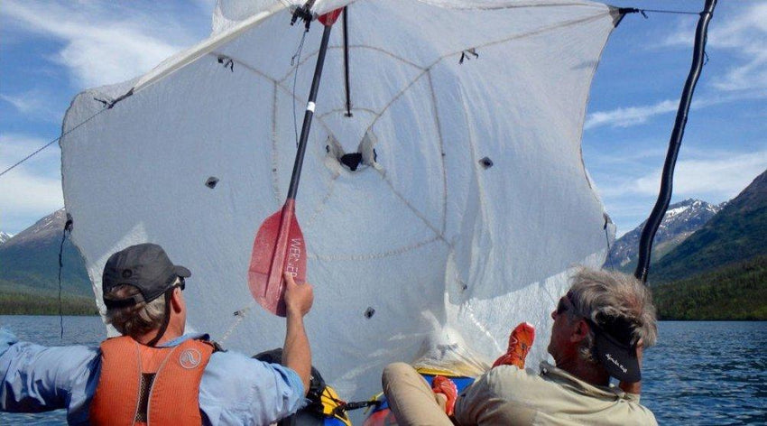
Day 6:
We again rigged the sail craft and made even better time than on Kontrashibuna; five miles in an effortless hour and a half. At one point Brad’s Gaia GPS said we were going 5.1 mph as we cruised the narrow channel called the “Big Chutes” between the mainland and Porcupine Island.
A mile from the town of Pedro Bay we broke apart and paddled independently to shore. Tickled from our sail, the views, and the Pile’s wonderful whitewater, I felt better about answering Brad’s original question.
Despite the gnarly brush, `Pile It On’ is the best classic-style packrafting trip in Lake Clark Park.
The post Pile It On – Packrafting a First Descent in Lake Clark National Park, Alaska appeared first on Hyperlite Mountain Gear Blog.